Bougainville
A French sailing ship, a German U-boat and one of the last generations of commercial cargo vessels to cross the oceans under sail.
By 1916 the age of commercial sail was drawing to a close, but it was not quite over. While dreadnoughts and submarines fought a new kind of war at sea, large sailing ships were still carrying cargo across the world's oceans. The French barque Bougainville was one of them.
Her final voyage took her to within 25 kilometres of Hook Head on the south-east coast of Ireland. There, on 22 March 1916, after weeks of bad weather had kept her close to the Irish coast, she encountered the German submarine U-70.
A survivor from the age of sail
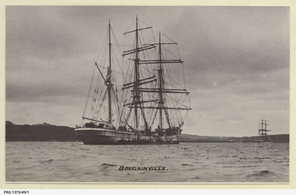
Bougainville was a three-masted French barque of the "Amiral-Courbet" type, built by Chantiers Nantais de Constructions Maritimes at Chantenay-sur-Loire for Bureau Frères & Baillergeau. She was launched on 20 July 1902.
At 2,248 gross tons, 84.6 metres long and 12.3 metres across the beam, she was no small sailing vessel. Ships such as Bougainville represented the final development of the commercial sailing ship: large steel-hulled vessels designed to move bulk cargo economically over enormous distances.
A wartime voyage around the world
The outbreak of the First World War initially brought Bougainville's movements to a halt. She remained immobilised until 19 November 1914, when she finally sailed for Australia by way of the Cape of Good Hope.
From Australia her voyage continued across the Pacific to San Francisco. There she loaded a cargo of corn for the return journey across the Atlantic, eventually reaching Falmouth on 7 February 1916.
By then the ship had effectively made a wartime circumnavigation of much of the globe under sail. Her next voyage would be considerably shorter.
Chartered by the British government for another grain voyage, Bougainville left port on 12 February 1916. A succession of strong gales prevented her making normal progress and kept the ship close to the Irish coast for more than a month.
U-70
On 22 March 1916, Bougainville was on her way to Runcorn with a cargo of barley when she encountered the German submarine U-70.
Rather than being torpedoed, the sailing ship was attacked with gunfire. Bougainville was hit and sunk approximately 25 kilometres south-west of Hook Head.
There were no casualties.
It is an encounter which neatly captures the extraordinary technological overlap of the First World War at sea. Bougainville was a traditional three-masted cargo ship whose basic means of propulsion had been familiar for centuries. The vessel that sank her was a submarine, part of a form of warfare that had barely existed a generation earlier.
Both were operating in the same waters in 1916.
The wreck today
Bougainville now lies in approximately 62 metres of water at 51° 54′ 48.41″ N, 7° 00′ 05.14″ W. Modern INFOMAR seabed surveys show the wreck lying upright on the seabed.
Although the overall wreck remains coherent, much of the structure has broken down. The survey identifies several areas of higher relief around the bow, while the surviving wreck visible on the seabed extends for roughly 61 metres.
More than a century underwater has therefore changed the ship considerably. The 84-metre barque which sailed from France, Australia and California survives as a much lower and shorter archaeological site, its hull gradually collapsing into the surrounding seabed.
Seeing Bougainville again
INFOMAR surveyed the site as part of survey CV13_01, producing high-resolution bathymetric imagery of the wreck. At 50 centimetre resolution, the remains of the ship can be picked out clearly from the otherwise relatively featureless seabed.
Water-column sonar and three-dimensional visualisation provide another perspective. Instead of the flattened outline visible from directly above, they show the remaining structure rising from the seabed, particularly around the bow.
It is perhaps a fitting way to encounter Bougainville today. She was not a famous liner, a battleship or the scene of a great maritime disaster. She was a working cargo vessel, one of thousands that carried goods around the world and have largely disappeared from memory.
For more than a century she has lain off the Irish coast, but modern seabed mapping makes it possible to see the outline of this almost forgotten sailing ship once again.
Survey and protection
The wreck was surveyed by INFOMAR as part of survey CV13_01. The survey includes shaded-relief bathymetry, 50 cm resolution imagery, water-column data and a three-dimensional visualisation of the wreck.
As Bougainville is more than 100 years old, the wreck is protected under Irish archaeological legislation. A licence is required to dive the site.
Explore the wreck
Open Bougainville directly on the Ireland wreck map and explore the surrounding seabed.
Zoom to Bougainville