RMS Lusitania
More than a century after her loss, modern seabed mapping reveals what remains of one of the world's most famous shipwrecks.
Few shipwrecks need less introduction than RMS Lusitania. Her sinking on 7 May 1915 has been written about for more than a century: the torpedo fired by U-20, the second explosion, the extraordinary speed with which the ship went down and the enormous loss of life. Less familiar is what happened afterwards.
Today Lusitania lies around 22 kilometres south of the Old Head of Kinsale, in 92 metres of water. Modern seabed surveys show not the great four-funnelled liner familiar from photographs and postcards, but a vast, increasingly collapsed structure lying on its side on the seabed.
The wreck has, in effect, acquired a history of its own.
Eighteen minutes
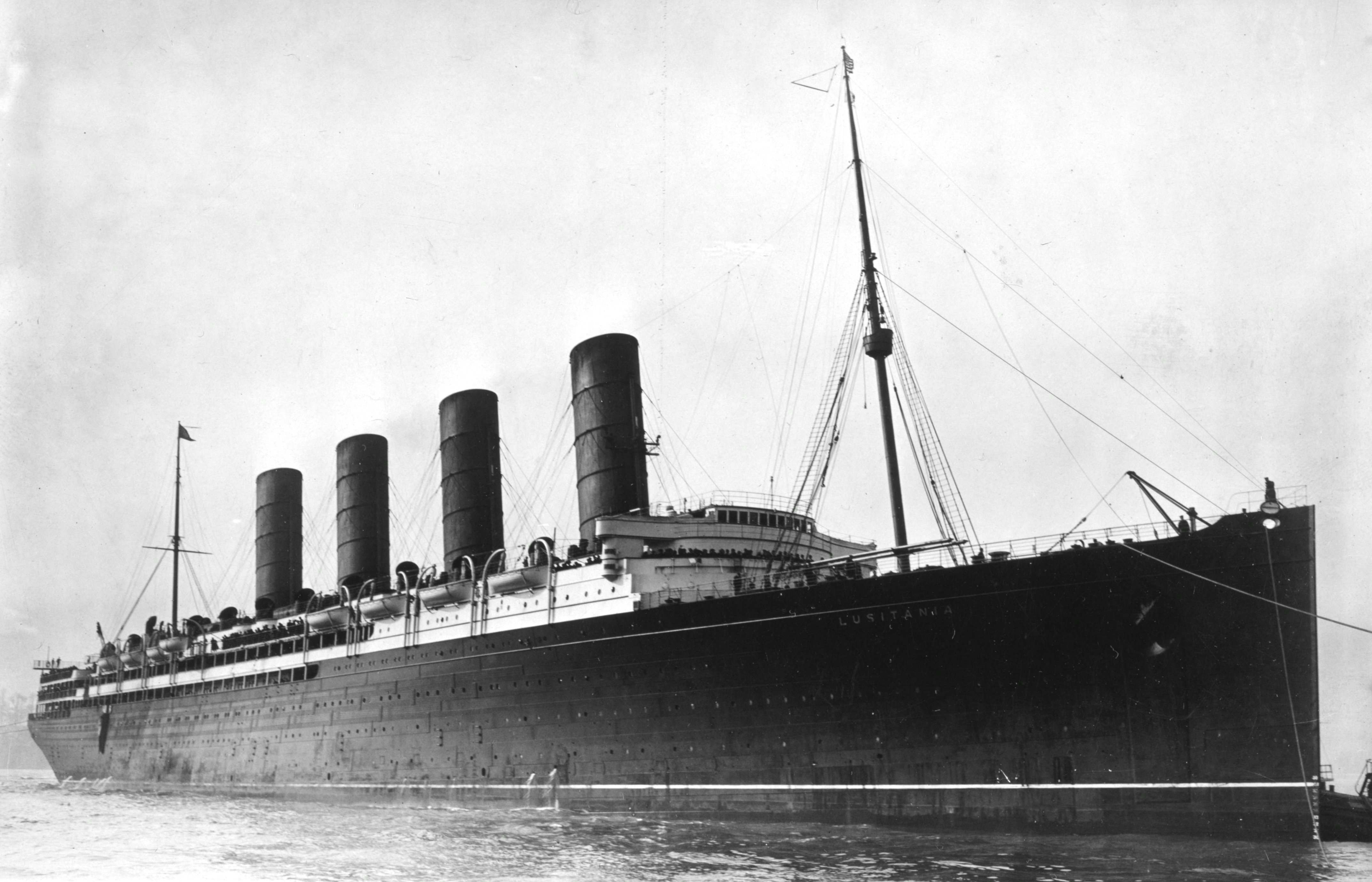
Lusitania was built in 1906 by John Brown & Co. of Glasgow for Cunard. At the time she was the largest ship yet built and, together with her sister Mauretania, represented an extraordinary piece of Edwardian engineering. She was capable of around 25 knots and incorporated electric steering, fire detection and remotely operated watertight doors.
On the afternoon of 7 May 1915 she was approaching the end of a crossing from New York to Liverpool when she was sighted by the German submarine U-20, commanded by Kapitänleutnant Walther Schwieger.
A single torpedo struck the starboard side, beneath or just aft of the bridge. It was followed by a second explosion somewhere in the forward part of the ship. Lusitania developed a heavy list and sank in only eighteen minutes. Of those aboard, 1,198 were killed and 764 survived.
That part of the story is well known. What happened to the ship after she reached the seabed is rather less so.
A liner becomes a wreck
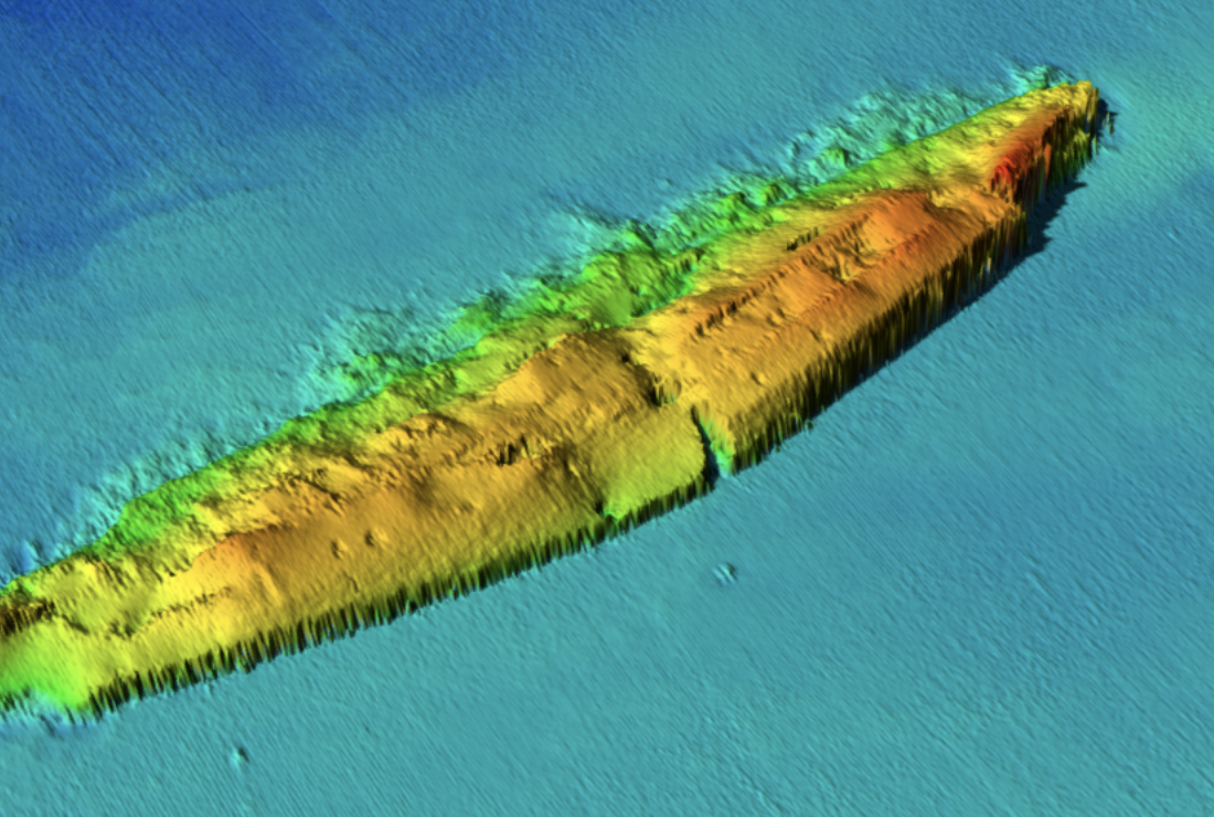
Lusitania's original dimensions were approximately 232 metres long, 27 metres wide and 17 metres high. On the seabed, however, the wreck now occupies an area approximately 241 metres long and 46 metres wide, with a maximum surviving height of 14.7 metres.
That difference is a useful reminder that a wreck is not simply a ship sitting on the bottom.
The neat hull dimensions have given way to a much broader field of collapsed and displaced structure. Lusitania lies roughly north-east to south-west, with her bow pointing north-east, and rests on her starboard side. Rather frustratingly for anyone hoping that modern survey techniques might finally reveal the physical evidence of the attack, this means that the part of the hull struck by Schwieger's torpedo is concealed beneath the wreck.
The image produced by modern seabed mapping is consequently quite different from the ship we know from photographs. The funnels and towering superstructure have gone. Decks have collapsed and the hull has spread across the seabed. Yet the overall form remains immediately recognisable as an enormous ship.
Particularly striking is the bow, which still stands proud of the surrounding seabed. Despite the deterioration of the wreck, numerous structural features remain discernible.
The damage did not end in 1915
Perhaps the more surprising part of Lusitania's story is that not everything visible in the wreck today can be attributed to her violent sinking.
The site has been subjected to a succession of salvage operations. It has endured a century of corrosion, collapse and the considerable energy of the North Atlantic.
And then there are the depth charges.
INFOMAR records that the wreck was depth-charged by the Royal Navy in the late 1940s. Combined with the violence of the original sinking, later salvage and natural deterioration, this has taken a substantial toll on the remains. The wreck continues slowly to collapse in upon itself.
It makes interpreting the wreck rather more complicated than simply looking for evidence of what happened during those eighteen minutes in May 1915. What lies off Kinsale is the product of the sinking and everything that has happened during the century since.
The seabed itself has become part of the story.
Seeing Lusitania differently
This is where modern bathymetric surveying becomes particularly interesting.
A shipwreck such as Lusitania is usually encountered through photographs of the ship while she was alive, contemporary illustrations of her sinking, or images taken by divers and remotely operated vehicles. Multibeam bathymetry gives a quite different perspective: the entire wreck can be seen as a feature of the seabed.
INFOMAR's survey imagery shows the full footprint of the wreck and the way in which its surviving structure rises above the surrounding sea floor. Rather than attempting to reconstruct Lusitania as she appeared in 1915, it records the ship as she exists now.
The imagery used here comes from INFOMAR survey KRY10_02, Kinsale, part of Ireland's programme of seabed mapping.
There is something slightly sobering about seeing Lusitania this way. The ship which once measured more than 230 metres from bow to stern, carried thousands of passengers across the Atlantic and became one of the defining maritime losses of the First World War is now gradually becoming part of the seabed. But she is not there yet.
More than a century after the sinking, the bow still rises from the bottom and the enormous outline of the liner can still be followed across the survey data. The familiar ship has gone, but enough survives that Lusitania remains unmistakable.
Not as she was on 7 May 1915, but as she is now.
Survey and further information
The seabed imagery and wreck measurements used on this page are derived from INFOMAR survey KRY10_02, Kinsale. INFOMAR is Ireland's national seabed mapping programme and provides high-resolution bathymetric survey data for Irish waters.
The wreck of RMS Lusitania is a protected archaeological site. Diving and other activities affecting the wreck are subject to licensing by Ireland's National Monuments Service.
Explore the wreck
Open RMS Lusitania directly on the Ireland wreck map and explore the surrounding high-resolution bathymetry.
Zoom to RMS Lusitania