PHOENIX 202
A concrete caisson built for the Mulberry artificial harbours in 1944, lost while under tow around Land's End and still lying substantially intact on the seabed off Cornwall.
About two and a half miles north-west of Land's End lies a wreck which is difficult to mistake for a ship. The seabed survey shows a long rectangular structure with almost parallel sides and a remarkably regular outline, measuring roughly 75 metres from end to end. It is PHOENIX 202, identified in wartime records as Ax-202, one of the large reinforced-concrete caissons constructed for the Mulberry artificial harbour programme during the Second World War.1
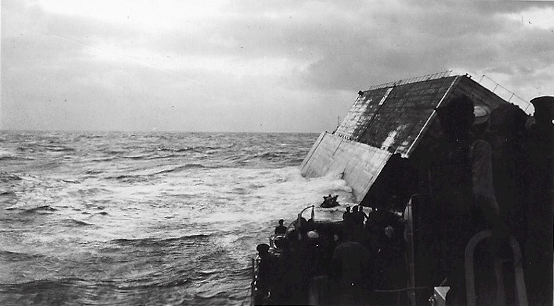
PHOENIX 202 never reached the coast of Normandy. It was being towed from Swansea in September 1944 when it developed problems during the passage around western Cornwall and foundered off Land's End. Its position makes it an unusual survival of the Mulberry programme: not part of the harbour at Arromanches and not one of the Phoenixes later reused around the British coast, but a prefabricated section of military harbour which came to rest permanently on the route to France.1
The Mulberry problem
The Phoenix caissons were developed in response to one of the central logistical problems of the Normandy invasion. Landing troops on an open beach was only useful if a much larger flow of vehicles, ammunition, fuel, equipment and food could be maintained behind them. A major port would eventually be necessary, but the Allies could not assume that a suitable harbour could be captured quickly or that its installations would survive German demolition. The raid on Dieppe in 1942 had already demonstrated the difficulty of attacking a strongly defended port directly from the sea.3
The Mulberry scheme was an attempt to provide much of the functionality of a harbour without first having to capture one. Two artificial harbours were constructed off the Normandy beaches: Mulberry A off Omaha for the American forces and Mulberry B off Gold Beach at Arromanches for the British and Canadian sector. They were assembled from a collection of prefabricated and deliberately sunk components which together provided sheltered water, floating roadways and pierheads from which cargo could be unloaded directly from ships.3
The scale of the project is easy to underestimate because its individual components are usually discussed separately. Historic England records that around 4,500 men were involved in constructing the two harbours. The completed systems incorporated floating breakwaters known as Bombardons, old vessels deliberately sunk as Gooseberry breakwaters, floating Whale roadways supported by Beetle pontoons and pierheads mounted on adjustable Spud legs. The Phoenix caissons formed the principal solid breakwater and were among the largest individual structures involved in the scheme.4
The Phoenix caissons
A Phoenix was essentially a very large reinforced-concrete vessel designed to have a deliberately short working life as a vessel. Internally it was divided into compartments and, while those compartments remained dry, the complete structure possessed enough buoyancy to float. Tugs could therefore move it from its construction site to the assembly area and eventually across the Channel. Once correctly positioned off Normandy, flooding valves were opened and the caisson was lowered onto the seabed, where it became a permanent part of the breakwater.2
Different classes of Phoenix were constructed for different water depths, but all were substantial structures. More than two hundred were ordered, with construction distributed between civil engineering contractors and sites around Britain. They were an unusual combination of marine and civil engineering: they needed to survive launching and towing like a vessel, but their actual purpose was to be sunk and behave as harbour infrastructure.2
The surviving Phoenix caissons at Portland give a useful indication of their construction. Historic England describes the internal transverse subdivision, access arrangements and provision for defensive equipment, including anti-aircraft positions. Two of the Portland examples are now Grade II listed, partly because of their direct association with the Mulberry project and partly because so much of the original structure survives.4
From Swansea to Normandy
PHOENIX 202 belonged to a later group of caissons produced after the first Mulberry harbours had already been established. Research published by The Crete Fleet identifies it as Ax-202, constructed by Pauling at Palmers Dock in Swansea alongside Ax-203. Both were completed as part of the continuing requirement for Phoenix units during the second half of 1944.1
By September the military situation was quite different from the weeks immediately following D-Day. The Allied armies had broken out of Normandy and were advancing across France, but Mulberry B at Arromanches remained in intensive use. Its importance had outlasted the temporary role originally envisaged for it, and additional Phoenix caissons were required to reinforce and maintain the breakwaters. Later units therefore continued to be dispatched to Normandy even as the campaign moved farther east.2
For Ax-202 and Ax-203 this meant being towed from Swansea, out through the Bristol Channel and around the western end of Cornwall before a Channel crossing could even begin. This was a substantial sea passage for structures which had no means of propulsion and relatively little in common with conventional vessels beyond their temporary ability to float. Their safe passage depended upon the integrity of the concrete hull and, in particular, upon keeping the internal compartments dry until deliberate flooding took place at the destination.
Loss off Cornwall
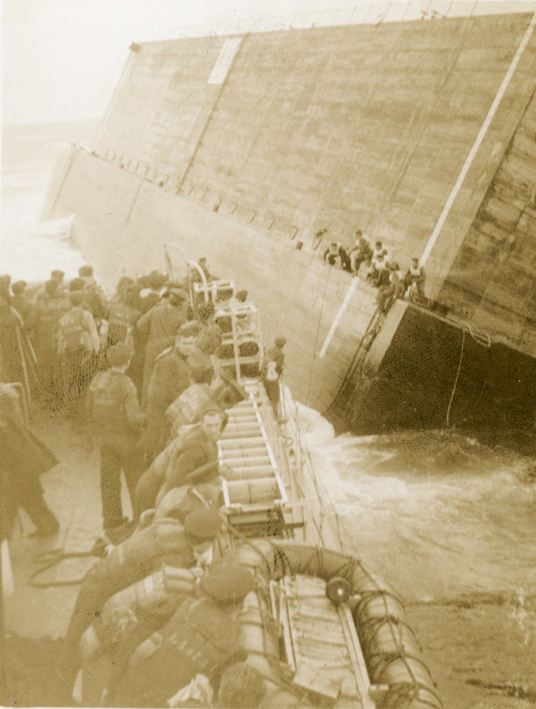
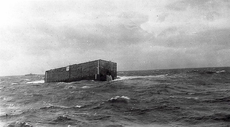
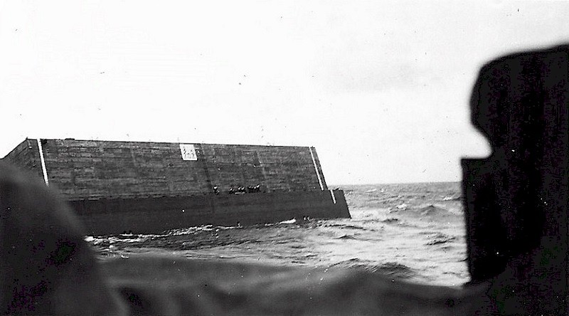
Both Swansea-built units were lost on 25 September 1944. The archival material located by The Crete Fleet records that “Ax Phoenix 202 and APD 203 were lost due leaking ports in transit”, with the reference to APD 203 considered likely to be a clerical error for Ax-203. Although brief, the entry provides a plausible explanation for the loss of two structures whose buoyancy depended upon controlling water entering their internal compartments.1
Ax-202 foundered approximately 2.3 nautical miles north-west of Land's End. Ax-203 survived farther around the Cornish coast before sinking approximately 2.5 nautical miles south-east of Mousehole. Their positions are therefore unusually informative. These were not caissons lost together at an anchorage or during an attempted Channel crossing, but two members of the same construction batch lost on the same day at different stages of the passage around the Land's End peninsula.1
The loss also illustrates one of the compromises inherent in the Phoenix design. The same ability to admit seawater which allowed a caisson to be sunk rapidly and predictably at Normandy became a liability if flooding occurred prematurely while it was being towed. Once a structure of this size began to lose its reserve buoyancy, there was little prospect of treating it in the same way as a damaged ship or towing it into a convenient harbour for repairs.
The wreck record
PHOENIX 202 did not disappear from the record for long. A hydrographic survey on 4 July 1945 recorded a substantial obstruction at roughly 50°06′N, 5°46′W. The object was estimated to be approximately 250 feet long and 100 feet wide and to rise about 57 feet above the surrounding seabed. Despite the limitations of the survey, the recorded length of about 76 metres is remarkably close to that obtained from modern high-resolution survey.1
A further survey in September 1977 described a tabular object in approximately 55 metres of water, with one end apparently damaged. That survey produced a considerably greater length of about 103 metres, but later work suggests that this probably included surrounding debris or an enlarged acoustic contact rather than the caisson itself. The consistently rectangular character of the target nevertheless made its interpretation quite different from that of a conventional wreck.1
Multibeam survey in October 2009 provides the clearest set of dimensions. The wreck was located at approximately 50°06.106′N, 5°46.260′W, on a seabed about 55.5 metres deep. The surviving structure measured approximately 74.5 metres long, 19 metres wide and 5.6 metres high, with a least depth of about 49.9 metres. It lies broadly east-north-east to west-south-west and was described as generally intact, although debris is present nearby.1
Wreck: PHOENIX 202 / Ax-202
Position: approximately 50° 06.106′ N, 5° 46.260′ W
Measured length: approximately 74.5 metres
Measured width: approximately 19 metres
Maximum surviving height: approximately 5.6 metres
Surrounding seabed: approximately 55.5 metres
Lost: 25 September 1944
Reading the caisson on the seabed
The multibeam imagery makes PHOENIX 202 an unusually straightforward wreck to interpret. Shipwrecks generally lose the regular geometry of the vessel from which they originated as decks collapse, hull plating spreads and machinery becomes exposed. A Phoenix caisson began as a rectangular concrete cellular structure and the wreck still retains much of that geometry. Its parallel sides, substantial width and abrupt ends are consequently visible in the seabed data without any need to reconstruct the original object from scattered components.
This also helps explain why early hydrographic surveys described it simply as a large tabular obstruction. There was very little about its shape to suggest a conventional maritime casualty. It had no bow, stern, engine room or cargo spaces in the usual sense, because it was never intended to function as a ship. Its floating phase was simply the means by which a prefabricated piece of harbour could be moved from a British construction site to the Normandy coast.
Once a Phoenix reached its intended position, sinking was not a casualty but the final stage of construction. The examples at Arromanches demonstrate the result particularly clearly: the caissons stand in a line offshore, each separate concrete structure forming part of a much larger artificial breakwater. PHOENIX 202 survives in much the same physical form, but in considerably deeper water and several hundred miles short of the place for which it was built.
What happened to the Mulberries
The two Mulberry harbours had very different histories. Mulberry A off Omaha Beach was badly damaged by the severe Channel storm of 19–22 June 1944 and subsequently abandoned. Mulberry B at Arromanches survived and remained in use for substantially longer than originally planned. The surviving figures vary slightly between accounts, but Historic England records more than 2.5 million men, 500,000 vehicles and four million tonnes of supplies passing through the harbour before it ceased operating.34
The Phoenixes themselves had useful lives beyond Normandy. Ten were placed at Portland in 1946 as part of improvements to the harbour. Following the disastrous North Sea flood of 1953, eight of those were subsequently taken to the Netherlands and used to close breaches in the Dutch sea defences. The two remaining Portland examples survive today as listed structures. Other Phoenixes remain around the British coast, while those still visible off Arromanches preserve the most complete impression of their original wartime purpose.4
The Crete Fleet's research has identified thirteen Phoenix caissons which were lost before reaching their intended destinations. That is a relatively small proportion of the total number constructed, particularly given that some units had to be towed considerable distances around the British coast before they even approached Normandy. PHOENIX 202 belongs to this much smaller group of accidental losses rather than to the surviving harbour structures themselves.1
PHOENIX 202 today
PHOENIX 202 is therefore best understood not simply as a wartime obstruction or as an unusual concrete wreck, but as surviving infrastructure from a specific part of the Normandy invasion programme. Its construction at Swansea, its intended movement to France and its loss off Land's End can all be connected with the continuing maintenance of the Mulberry system during the months after D-Day.
That context also explains the unusual completeness of the wreck. The object on the seabed is not the remains of a vessel which happened to be made from concrete. It is a prefabricated section of breakwater which happened, temporarily, to float. The approximately 75-metre rectangular structure visible in modern bathymetry is consequently very close to the form it was intended to have once permanently installed on the seabed.
The principal difference is geographical. Instead of forming part of the artificial harbour off Normandy, Ax-202 came to rest off western Cornwall on 25 September 1944. More than eighty years later, its position and surviving form preserve an otherwise easily overlooked part of the logistical undertaking behind the Mulberry harbours: not only their construction and successful operation, but the difficult process of moving hundreds of enormous prefabricated structures from British yards to the French coast.
Explore the wreck
Open PHOENIX 202 directly on the Wrecksite map to view its position north-west of Land's End and the surrounding seabed.
Zoom to PHOENIX 202Sources and further reading
- The Crete Fleet, Phoenix Caissons – Where Are They Now? – Lost En Route, Part 2 . Used as the principal source for the identification of Ax-202, its construction at Swansea, the loss of Ax-202 and Ax-203, and the historical hydrographic survey record.
- Wikipedia, “Phoenix breakwaters” . Used for general background on the design, construction and deployment of the Phoenix caissons.
- Wikipedia, “Mulberry harbours” . Used for general background on the development and operation of Mulberry A and Mulberry B and the wider artificial harbour system.
- Historic England, “Two Phoenix Caissons, Portland Harbour” , National Heritage List for England entry 1203075. Used for the construction and historical significance of the Phoenix caissons, the Mulberry harbour programme and the surviving Portland examples.